|
|
     aHR0cDovL2ZyZWVzaGlwLmNvLmty aHR0cDovL2ZyZWVzaGlwLmNvLmty
- 비디오 캡처 해상도: 6K UHD
- 운영자 기술 수준: Beginner
- 실내/실외 사용: 실내 야외
- 카메라 마운트 유형: 3 축 짐벌
- 컨트롤러 모드: MODE1
- 증명서: 세륨
- 작동 시간: 30 mins
- 컨트롤러 배터리: 3
- 제어 채널: 4채널
- 모터: 브러시리스 모터
- 충전 시간: 4 hours
- 원거리: 3000M
- 원격 제어: 그렇습니다
- 유형: HELICOPTER
- 공중 사진: 그렇습니다
- 패키지 구성: 원래 상자,Camera,배터리,원격 컨트롤러,충전기,USB 케이블,작동 지침
- 재료: 플라스틱,금속
- 특징: App 제어,자동 복귀,따라와,FPV 할,GPS,통합 카메라,장애물 회피,Wi-Fi
- 브랜드 이름: BAANFU
- 근원: CN (정품)
- 추천 나이: 12 + y
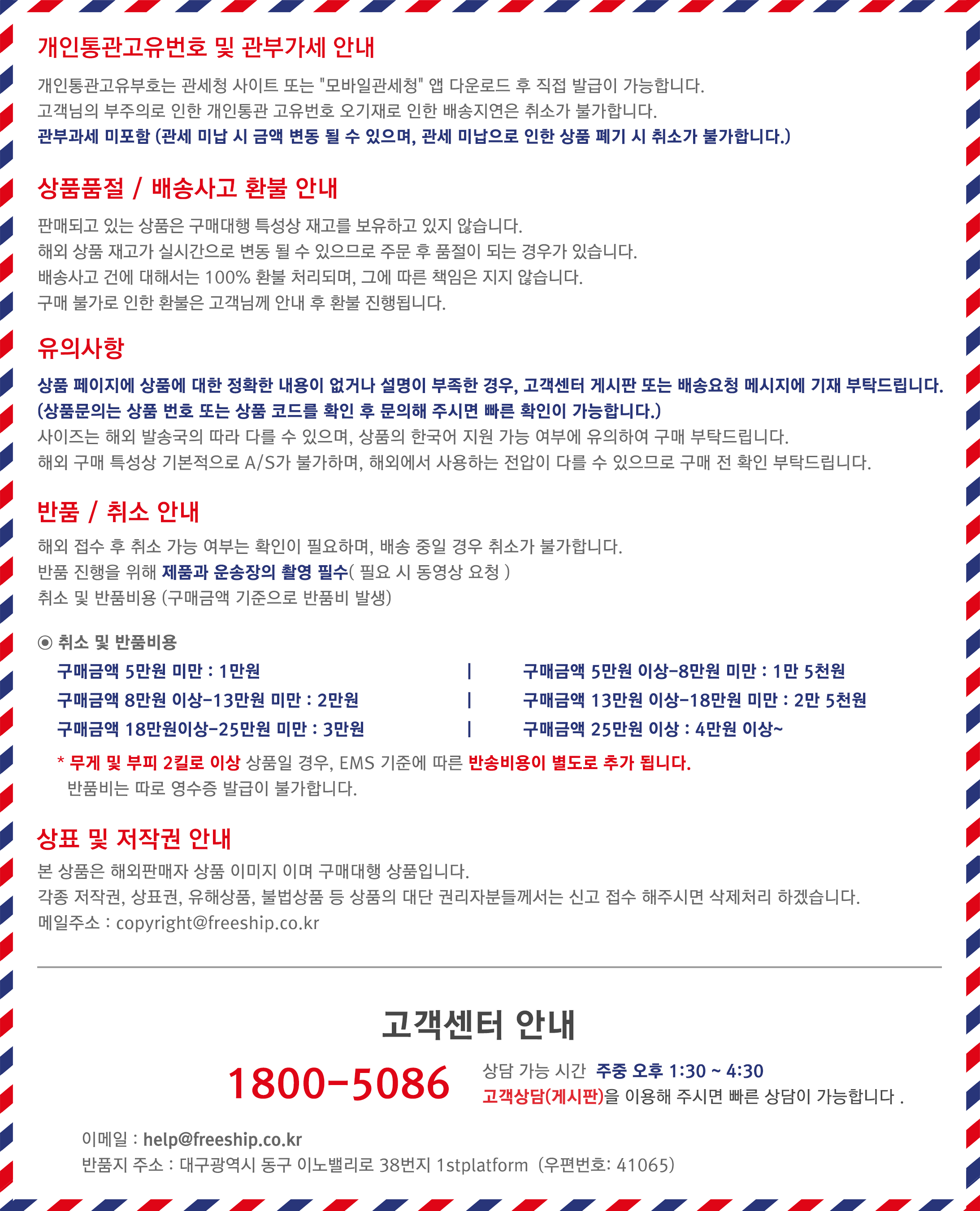
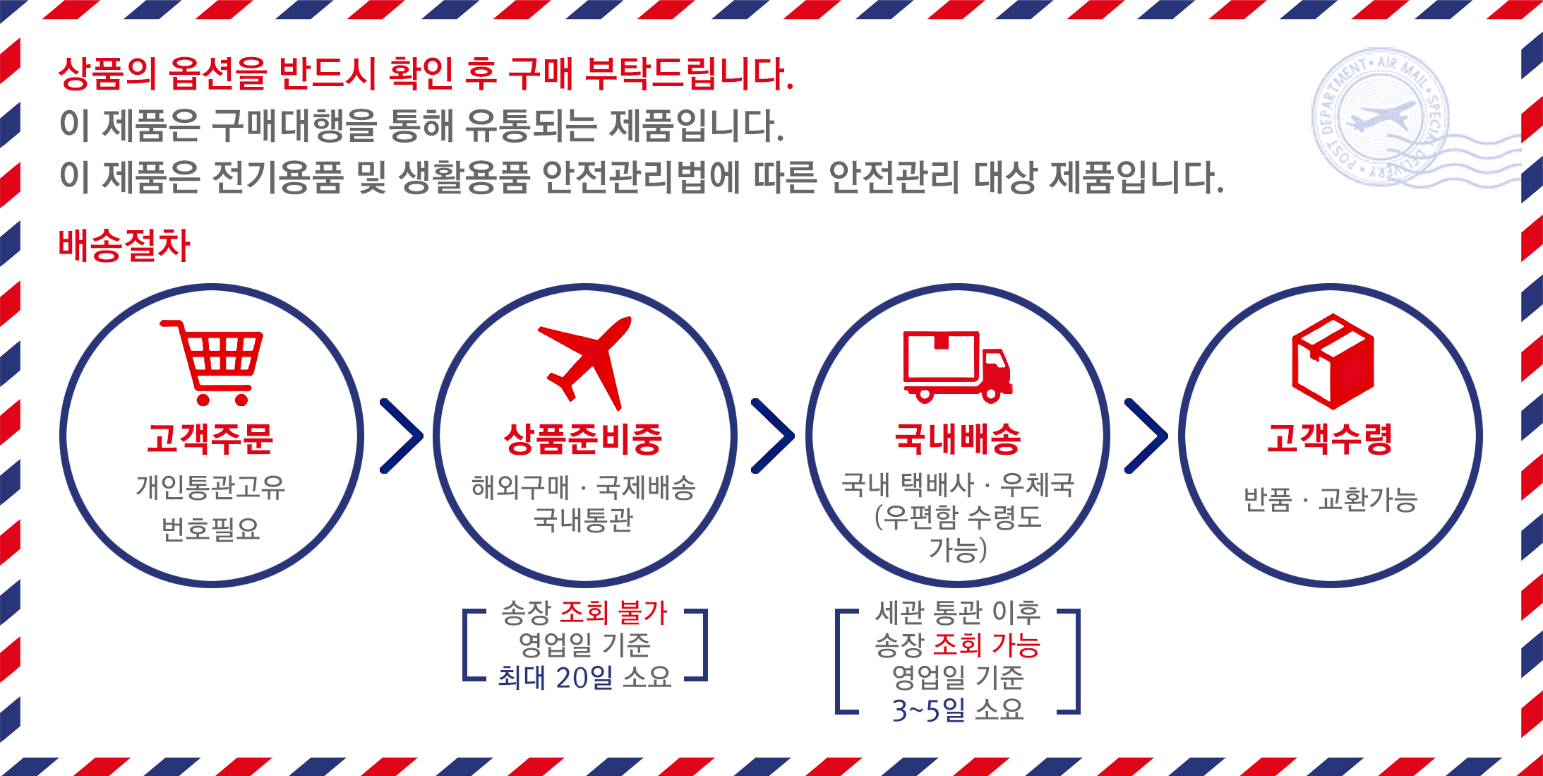
옵션정보[(691)6K GPS 5G 1B Bag] [(100018786)6K GPS 5G 2B Bag] [(100018786)6K GPS 5G 2B Bag] [(350853)6K GPS 5G 3B Bag] [(350853)6K GPS 5G 3B Bag] Product name: F9 four-axis GPS brushless folding aircraft Packing method: storage bag 28*9.5*21cm weight 580g Body battery capacity: 7.4V 2500mAh 50g Product unfolded size: 26*6*31cm 5.8G signal Product folded size: 14*9*6CM Battery charging time: about 240 minutes Flight time: about 30 minutes Aircraft range map transmission 3000 meters Product selling points: 1. GPS1 key to return to the take-off point, low power return, no signal return. 2. ① GPS intelligent follow; ② Image follow: recognize the GPS signal to automatically follow the flight. 3. Gesture shooting recognition: within 1-3m from the aircraft, make a photo gesture/camera gesture facing the camera. 4. Route multi-point planning flight: The aircraft flies autonomously according to the set route, and the player shoots. 5. Fixed point surround: find the center point of the surround, and then use the joystick to move the desired surround radius. 6. Aircraft retrieval function: Click the GPS signal icon 3 times continuously to open the map interface, the map displays the distance, latitude and longitude of the aircraft. 7. Picture and video sharing: You can single-select or multiple-select to share photos, and videos can only be shared individually at a time.                   
|
|
|
|
|


 배송기간
배송기간